
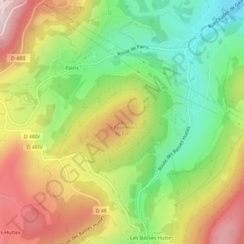
Le Noirmont topographic map
Interactive map
Click on the map to display elevation.
About this map
Name: Le Noirmont topographic map, elevation, terrain.
Average elevation: 728 m
Minimum elevation: 515 m
Maximum elevation: 977 m
Other topographic maps
Click on a map to view its topography, its elevation and its terrain.
Col du Wettstein
Col du Wettstein, Route des Basses Huttes, Gazon l'Hôte, Orbey, Colmar-Ribeauvillé, Haut-Rhin, Grand Est, France métropolitaine, 68370, France
Average elevation: 848 m
Col du Wettstein
Col du Wettstein, Route des Basses Huttes, Gazon l'Hôte, Orbey, Colmar-Ribeauvillé, Haut-Rhin, Grand Est, France métropolitaine, 68370, France
Average elevation: 847 m