
Make a donation
Gear up for your next adventure:
As an Amazon Associate, this site earns from qualifying purchases at no extra cost to you.
Cardiff topographic map
Click on the map to display elevation.
Make a donation
Gear up for your next adventure:
As an Amazon Associate, this site earns from qualifying purchases at no extra cost to you.
About this map
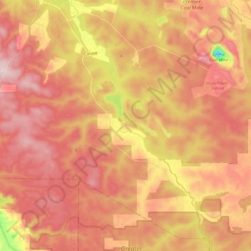
Name: Cardiff topographic map, elevation, terrain.
Location: Cardiff, Shire Of Collie, West-Australië, Australië (-33.55249 116.13213 -33.40161 116.33323)
Average elevation: 236 m
Minimum elevation: 52 m
Maximum elevation: 337 m
Make a donation
Gear up for your next adventure:
As an Amazon Associate, this site earns from qualifying purchases at no extra cost to you.
Other topographic maps
Click on a map to view its topography, its elevation and its terrain.
Perth
Australië > West-Australië > City of Perth
Tussen 2005 en 2015 beleefde de mijnbouw in West-Australië weer hoogdagen. Na Japan in de jaren 1960-70 dreef nu China de grondstoffenvraag naar ongeziene hoogte. De bevolking van de stad groeide stevig en de infrastructuur evolueerde maar met moeite mee. Veel mijnwerkers woonden in de stad en werkten onder…
Average elevation: 26 m
Make a donation
Gear up for your next adventure:
As an Amazon Associate, this site earns from qualifying purchases at no extra cost to you.