
Hainhofen topographic map
Interactive map
Click on the map to display elevation.
About this map
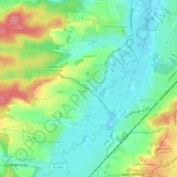
Name: Hainhofen topographic map, elevation, terrain.
Location: Hainhofen, Neusäß, Landkreis Augsburg, Bayern, Deutschland (48.37914 10.75748 48.39486 10.80822)
Average elevation: 486 m
Minimum elevation: 454 m
Maximum elevation: 544 m
Other topographic maps
Click on a map to view its topography, its elevation and its terrain.
Täfertingen
Deutschland > Bayern > Landkreis Augsburg > Neusäß
Täfertingen, Neusäß, Landkreis Augsburg, Bayern, Deutschland
Average elevation: 473 m
Steppach
Deutschland > Bayern > Landkreis Augsburg > Neusäß > Steppach
Steppach, Neusäß, Landkreis Augsburg, Bayern, Deutschland
Average elevation: 501 m