
Make a donation
Gear up for your next adventure:
As an Amazon Associate, this site earns from qualifying purchases at no extra cost to you.
Althengstett topographic map
Click on the map to display elevation.
Make a donation
Gear up for your next adventure:
As an Amazon Associate, this site earns from qualifying purchases at no extra cost to you.
Althengstett
Althengstett liegt in 450 bis 606 m Höhe im östlichen Nordschwarzwald in geringer Entfernung zum Landschaftsschutzgebiet Hecken- und Schlehengäu. Althengstett ist damit die höchstgelegene Gemeinde im Landkreis Calw östlich der Nagold. Das Köpfle stellt mit einer Höhe von 606 m die höchste natürliche Erhebung im Landkreis Calw östlich der Nagold dar. Die Althengstetter Erddeponie ist zwar deutlich höher (ca. 630 m ü. NN), sie wurde jedoch künstlich aufgeschüttet. Weitere Erhebungen auf Althengstetter Gemarkung sind.
Make a donation
Gear up for your next adventure:
As an Amazon Associate, this site earns from qualifying purchases at no extra cost to you.
About this map
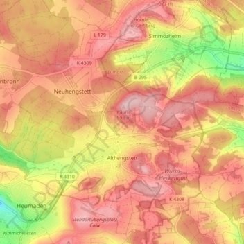
Name: Althengstett topographic map, elevation, terrain.
Average elevation: 528 m
Minimum elevation: 398 m
Maximum elevation: 599 m
Make a donation
Gear up for your next adventure:
As an Amazon Associate, this site earns from qualifying purchases at no extra cost to you.
Other topographic maps
Click on a map to view its topography, its elevation and its terrain.
Oberreichenbach
Deutschland > Baden-Württemberg > Landkreis Calw
Die Gemeinde liegt naturräumlich auf der Enz-Nagold-Platte zwischen 588 und 745 Meter Höhe, etwa jeweils 6 km von der Kreisstadt Calw und Bad Liebenzell entfernt. Sie gehört zur Region Nordschwarzwald. Mehr als 70 % des Gemeindegebiets sind bewaldet. Die nächsten größeren Städte in der Umgebung sind das…
Average elevation: 652 m
Make a donation
Gear up for your next adventure:
As an Amazon Associate, this site earns from qualifying purchases at no extra cost to you.