
Thank you for supporting this site ❤️
Make a donation
Make a donation
Gear up for your next adventure:
As an Amazon Associate, this site earns from qualifying purchases at no extra cost to you.
Missipi topographic map
Click on the map to display elevation.
Thank you for supporting this site ❤️
Make a donation
Make a donation
Gear up for your next adventure:
As an Amazon Associate, this site earns from qualifying purchases at no extra cost to you.
About this map
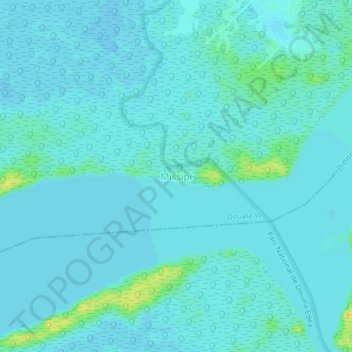
Name: Missipi topographic map, elevation, terrain.
Average elevation: 5 m
Minimum elevation: 1 m
Maximum elevation: 25 m
Thank you for supporting this site ❤️
Make a donation
Make a donation
Gear up for your next adventure:
As an Amazon Associate, this site earns from qualifying purchases at no extra cost to you.
Other topographic maps
Click on a map to view its topography, its elevation and its terrain.
Île Manoka
Cameroon > Littoral > Wouri > Douala VI
The island has an average elevation of 12 meters and 70% of the island has is below 10m above sea level.
Average elevation: 4 m