Geolocate

El Chive topographic map

Click on the map to display elevation.

About this map

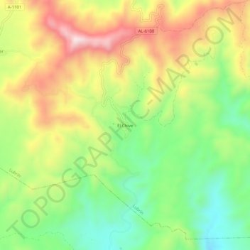
Name: El Chive topographic map, elevation, terrain.

Location: El Chive, Lubrín, Almería, Andalucía, 04271, España (37.15800 -2.09335 37.19800 -2.05335)

Average elevation: 598 m

Minimum elevation: 378 m

Maximum elevation: 870 m

Other topographic maps

Click on a map to view its topography, its elevation and its terrain.

Sierra de la Atalaya

España > Andalucía > Lubrín

Average elevation: 654 m

Gear up for your next adventure:

🥾Waterproof Hiking Shoes - Durable shoes for wet and rugged trails
🧭GPS Tracker - Track your location in remote areas safely
🧴Sunscreen SPF - Broad-spectrum sunscreen for outdoor activities
🥽Outdoor Goggles - Protective eyewear for outdoor activities
🧴Bear Spray Holster - Quick-access carry for essential Canadian wilderness safety

As an Amazon Associate, this site earns from qualifying purchases at no extra cost to you.