
Make a donation
Gear up for your next adventure:
As an Amazon Associate, this site earns from qualifying purchases at no extra cost to you.
Massabesic Lake topographic map
Click on the map to display elevation.
Make a donation
Gear up for your next adventure:
As an Amazon Associate, this site earns from qualifying purchases at no extra cost to you.
About this map
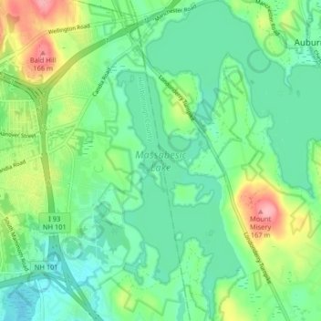
Name: Massabesic Lake topographic map, elevation, terrain.
Average elevation: 90 m
Minimum elevation: 56 m
Maximum elevation: 171 m
Make a donation
Gear up for your next adventure:
As an Amazon Associate, this site earns from qualifying purchases at no extra cost to you.
Other topographic maps
Click on a map to view its topography, its elevation and its terrain.
Manchester
United States > New Hampshire > Hillsborough County > Manchester
According to the United States Census Bureau, the city has a total area of 35.0 square miles (90.6 km2), of which 33.1 square miles (85.7 km2) are land and 1.9 square miles (4.8 km2) are water, comprising 5.33% of the city. Manchester is drained by the Merrimack River and its tributaries the Piscataquog River…
Average elevation: 126 m