
Make a donation
Gear up for your next adventure:
As an Amazon Associate, this site earns from qualifying purchases at no extra cost to you.
Rincon topographic map
Click on the map to display elevation.
Make a donation
Gear up for your next adventure:
As an Amazon Associate, this site earns from qualifying purchases at no extra cost to you.
About this map
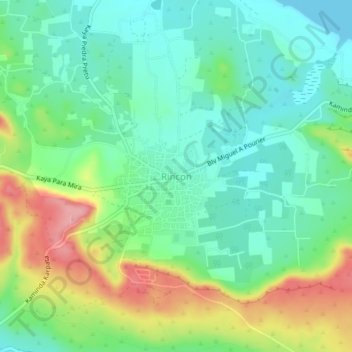
Name: Rincon topographic map, elevation, terrain.
Location: Rincon, Bonaire, Netherlands (12.21867 -68.34982 12.25867 -68.30982)
Average elevation: 40 m
Minimum elevation: 0 m
Maximum elevation: 119 m
Make a donation
Gear up for your next adventure:
As an Amazon Associate, this site earns from qualifying purchases at no extra cost to you.
Other topographic maps
Click on a map to view its topography, its elevation and its terrain.
Eindhoven
The villages and city that make up modern Eindhoven were originally built on sandy elevations between the Dommel, Gender and Tongelreep rivers. Beginning in the 19th century, the basins of the rivers themselves have also been used as housing land, resulting in occasional flooding in the city centre. Partly to…
Average elevation: 20 m
Saba
There is an 8.6 hectares (21 acres) cloud forest located at and above 825 metres (2,707 ft) on top of the mountain referred to as the "Elfin Forest Reserve" because of its high altitude mist and mossy appearance. The most dominant tree in the cloud forest is the Mountain Mahogany (Freziera undulate), although…
Average elevation: 2 m
Make a donation
Gear up for your next adventure:
As an Amazon Associate, this site earns from qualifying purchases at no extra cost to you.
Make a donation
Gear up for your next adventure:
As an Amazon Associate, this site earns from qualifying purchases at no extra cost to you.
Sint Eustatius
Sint Eustatius is 6 miles (10 km) long and up to 3 miles (5 km) wide. Topographically, the island is saddle-shaped, with the 602-meter-high dormant volcano Quill (Mount Mazinga), (from Dutch kuil, meaning 'pit'—originally referring to its crater) to the southeast and the smaller summits of Signal Hill/Little…
Average elevation: 12 m