
Make a donation
Gear up for your next adventure:
As an Amazon Associate, this site earns from qualifying purchases at no extra cost to you.
Yzeures-sur-Creuse topographic map
Click on the map to display elevation.
Make a donation
Gear up for your next adventure:
As an Amazon Associate, this site earns from qualifying purchases at no extra cost to you.
Yzeures-sur-Creuse
La confluence est marquée visuellement par une butte boisée qui partage les deux vallées et constitue un élément topographique majeur au cœur du territoire communal.
Make a donation
Gear up for your next adventure:
As an Amazon Associate, this site earns from qualifying purchases at no extra cost to you.
About this map
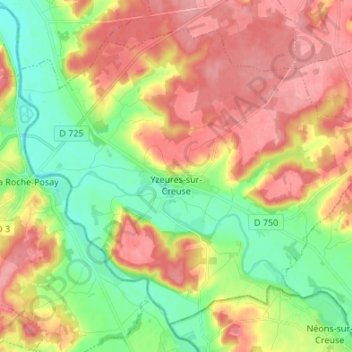
Name: Yzeures-sur-Creuse topographic map, elevation, terrain.
Average elevation: 95 m
Minimum elevation: 51 m
Maximum elevation: 139 m
Make a donation
Gear up for your next adventure:
As an Amazon Associate, this site earns from qualifying purchases at no extra cost to you.
Other topographic maps
Click on a map to view its topography, its elevation and its terrain.
Le Point du Jour
France > Centre-Val de Loire > Indre-et-Loire > Sainte-Maure-de-Touraine
Average elevation: 100 m
Le Gros Ormeau
France > Centre-Val de Loire > Indre-et-Loire > Cléré-les-Pins
Average elevation: 102 m
Make a donation
Gear up for your next adventure:
As an Amazon Associate, this site earns from qualifying purchases at no extra cost to you.
Les Évées
France > Centre-Val de Loire > Indre-et-Loire > Saint-Martin-le-Beau
Average elevation: 71 m
La Ville
France > Centre-Val de Loire > Indre-et-Loire > Sainte-Maure-de-Touraine
Average elevation: 97 m
Château
France > Centre-Val de Loire > Indre-et-Loire > Sainte-Maure-de-Touraine > La Ville
Average elevation: 92 m
Make a donation
Gear up for your next adventure:
As an Amazon Associate, this site earns from qualifying purchases at no extra cost to you.