Geolocate

Chaumeray topographic map

Click on the map to display elevation.

About this map
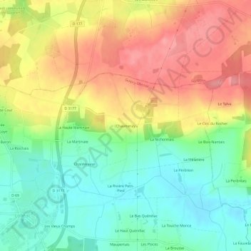
Name: Chaumeray topographic map, elevation, terrain.

Location: Chaumeray, Guipry, Guipry-Messac, Redon, Ille-et-Vilaine, Bretagne, France métropolitaine, 35480, France (47.86094 -1.88102 47.90094 -1.84102)

Average elevation: 72 m

Minimum elevation: 25 m

Maximum elevation: 125 m

Other topographic maps

Click on a map to view its topography, its elevation and its terrain.

Guipry

France > Bretagne > Ille-et-Vilaine > Guipry-Messac

Average elevation: 48 m

Gear up for your next adventure:

🧥Fleece Jacket - Warm and lightweight jacket for layering
🛌Down Sleeping Bag - Superior warmth-to-weight ratio for cold nights
🥽Outdoor Goggles - Protective eyewear for outdoor activities
🌡️Emergency Mylar Blankets - Compact thermal protection for unexpected nights outdoors
🦶Hiking Shoe Insoles - Added support for high arches and long days on feet

As an Amazon Associate, this site earns from qualifying purchases at no extra cost to you.