Geolocate

Arsu topographic map

Click on the map to display elevation.

About this map

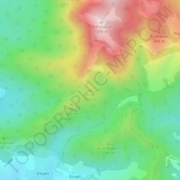
Name: Arsu topographic map, elevation, terrain.

Location: Arsu, Anue, Iruñerria, Navarre, 31698, Spain (42.94303 -1.56635 42.94313 -1.56625)

Average elevation: 761 m

Minimum elevation: 557 m

Maximum elevation: 1,096 m

Gear up for your next adventure:

👟Trail Running Shoes - Agile footwear for fast-paced topographic exploration
💡LED Headlamp - Hands-free illumination for night hiking and camping
🧭GPS Handheld Device - Reliable GPS navigation for outdoor adventures
🥾Trail Hiking Socks - Comfortable socks to prevent blisters and fatigue
🔨Vehicle Emergency Tool - Safety tool for remote road trips to trailheads

As an Amazon Associate, this site earns from qualifying purchases at no extra cost to you.