
Make a donation
Gear up for your next adventure:
As an Amazon Associate, this site earns from qualifying purchases at no extra cost to you.
North Wales topographic map
Click on the map to display elevation.
Make a donation
Gear up for your next adventure:
As an Amazon Associate, this site earns from qualifying purchases at no extra cost to you.
About this map
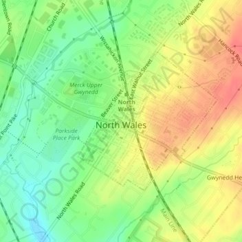
Name: North Wales topographic map, elevation, terrain.
Location: North Wales, Montgomery County, Pennsylvania, United States (40.20362 -75.28450 40.21917 -75.26415)
Average elevation: 113 m
Minimum elevation: 85 m
Maximum elevation: 141 m
Make a donation
Gear up for your next adventure:
As an Amazon Associate, this site earns from qualifying purchases at no extra cost to you.
Other topographic maps
Click on a map to view its topography, its elevation and its terrain.
Elkins Park Gardens
United States > Pennsylvania > Montgomery County > Cheltenham Township > Cheltenham
Average elevation: 70 m
Bala Cynwyd
United States > Pennsylvania > Montgomery County > Lower Merion Township
Average elevation: 75 m