
Make a donation
Gear up for your next adventure:
As an Amazon Associate, this site earns from qualifying purchases at no extra cost to you.
Harlingerode topographic map
Click on the map to display elevation.
Make a donation
Gear up for your next adventure:
As an Amazon Associate, this site earns from qualifying purchases at no extra cost to you.
Harlingerode
Harlingerode liegt nordwestlich der Kernstadt auf einer Höhe zwischen 190 m ü. NHN und 250 m ü. NHN am Steilhang des Langenbergs. Die Gemarkung ist zwischen 170 m ü. NHN (Okertal südlich Vienenburg) und 304 m ü. NHN (Soldatenkopf, Langenberg) hoch.
Make a donation
Gear up for your next adventure:
As an Amazon Associate, this site earns from qualifying purchases at no extra cost to you.
About this map
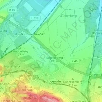
Name: Harlingerode topographic map, elevation, terrain.
Average elevation: 199 m
Minimum elevation: 158 m
Maximum elevation: 295 m
Make a donation
Gear up for your next adventure:
As an Amazon Associate, this site earns from qualifying purchases at no extra cost to you.
Other topographic maps
Click on a map to view its topography, its elevation and its terrain.