Geolocate

Sebring topographic map

Click on the map to display elevation.

About this map

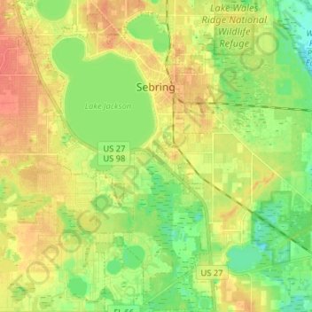
Name: Sebring topographic map, elevation, terrain.

Location: Sebring, Highlands County, Florida, United States (27.41266 -81.49922 27.52753 -81.41306)

Average elevation: 34 m

Minimum elevation: 14 m

Maximum elevation: 54 m

Other topographic maps

Click on a map to view its topography, its elevation and its terrain.

Venus

United States > Florida > Highlands County

Average elevation: 33 m

Gear up for your next adventure:

🧢Hiking Hat - Sun-protective and breathable hats for long treks
🥾Durable Hiking Shoes - Long-lasting shoes for frequent hiking
🛏️Camping Sleeping Mat - Comfortable mats for sleeping outdoors
🦯Trekking Poles - Reduced impact on joints for steep topographic climbs
🧭GPS Tracker - Track your location in remote areas safely

As an Amazon Associate, this site earns from qualifying purchases at no extra cost to you.