
Thank you for supporting this site ❤️
Make a donation
Make a donation
Gear up for your next adventure:
As an Amazon Associate, this site earns from qualifying purchases at no extra cost to you.
Nkolfoulou I topographic map
Click on the map to display elevation.
Thank you for supporting this site ❤️
Make a donation
Make a donation
Gear up for your next adventure:
As an Amazon Associate, this site earns from qualifying purchases at no extra cost to you.
About this map
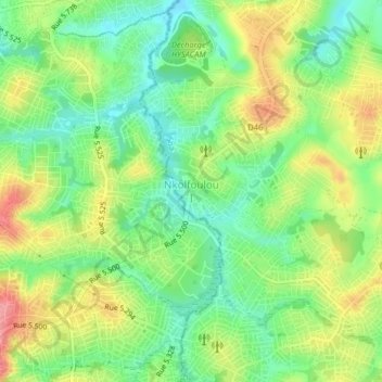
Name: Nkolfoulou I topographic map, elevation, terrain.
Location: Nkolfoulou I, Soa, Méfou-et-Afamba, Centre, Cameroon (3.89379 11.55078 3.93379 11.59078)
Average elevation: 689 m
Minimum elevation: 646 m
Maximum elevation: 750 m
Thank you for supporting this site ❤️
Make a donation
Make a donation
Gear up for your next adventure:
As an Amazon Associate, this site earns from qualifying purchases at no extra cost to you.