Geolocate

Tulcea topographic map

Click on the map to display elevation.

About this map

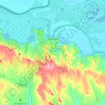
Name: Tulcea topographic map, elevation, terrain.

Location: Tulcea, Romania (45.05305 28.68709 45.24977 28.91299)

Average elevation: 51 m

Minimum elevation: -2 m

Maximum elevation: 220 m

Other topographic maps

Click on a map to view its topography, its elevation and its terrain.

Sălcioara

Romania > Tulcea

Average elevation: 16 m

Vasile Alecsandri

Romania > Tulcea

Average elevation: 258 m

Pătlăgeanca

Romania > Tulcea

Average elevation: 4 m

Islazu

Romania > Tulcea > Hamcearca

Average elevation: 184 m

La Tene

Romania > Tulcea > Cârjelari

Average elevation: 217 m

Lăstuni

Romania > Tulcea

Average elevation: 36 m

Pietrosu Mic

Romania > Tulcea > Luncavița

Average elevation: 308 m

Tulcea

Romania > Tulcea

Average elevation: 25 m

Dealul cu Drum

Romania > Tulcea > Greci

Average elevation: 168 m

Caraorman

Romania > Tulcea

Average elevation: 1 m

Țuțuiatu

Romania > Tulcea

Average elevation: 291 m

Tudor Vladimirescu

Romania > Tulcea > Tulcea

Average elevation: 15 m

Zebil

Romania > Tulcea > Zebil

Average elevation: 20 m

Cataloi

Romania > Tulcea

Average elevation: 58 m

Gear up for your next adventure:

🧭Orienteering Kit - Tools for map reading and navigation in the wild
🧥Thermal Layer - Insulating layer for cold outdoor conditions
🚲Handlebar Phone Mount - View topographic-map.com live while cycling
🧢Hiking Sun Hat - Wide-brimmed protection for exposed mountain ridges
🧦Crew Hiking Socks - Comfortable socks for long-distance hikes

As an Amazon Associate, this site earns from qualifying purchases at no extra cost to you.