
Make a donation
Gear up for your next adventure:
As an Amazon Associate, this site earns from qualifying purchases at no extra cost to you.
Richardson Springs topographic map
Click on the map to display elevation.
Make a donation
Gear up for your next adventure:
As an Amazon Associate, this site earns from qualifying purchases at no extra cost to you.
Richardson Springs
Richardson Springs (formerly, Mud Springs) is an unincorporated community in Butte County, California. It is located on Mud Creek 8.5 miles (13.7 km) north-northeast of Chico, at an elevation of 620 feet (189 m). The place is named for J.H. and Lee Richardson, who founded mineral spas here in 1898. A post office was opened in 1933.
Make a donation
Gear up for your next adventure:
As an Amazon Associate, this site earns from qualifying purchases at no extra cost to you.
About this map
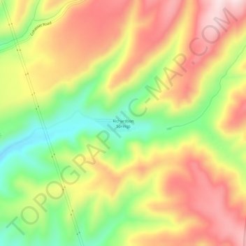
Name: Richardson Springs topographic map, elevation, terrain.
Average elevation: 335 m
Minimum elevation: 142 m
Maximum elevation: 509 m
Make a donation
Gear up for your next adventure:
As an Amazon Associate, this site earns from qualifying purchases at no extra cost to you.
Other topographic maps
Click on a map to view its topography, its elevation and its terrain.
Make a donation
Gear up for your next adventure:
As an Amazon Associate, this site earns from qualifying purchases at no extra cost to you.
Make a donation
Gear up for your next adventure:
As an Amazon Associate, this site earns from qualifying purchases at no extra cost to you.