Geolocate

Amberg topographic map

Click on the map to display elevation.

Amberg

In der Selgradstraße befindet sich der Friedhof für den Stadtteil Luitpoldhöhe.

About this map

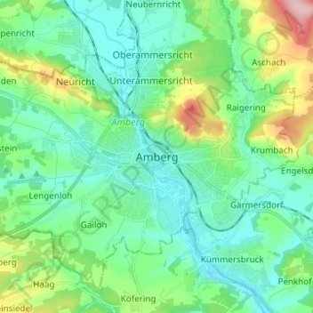
Name: Amberg topographic map, elevation, terrain.

Location: Amberg, Bayern, 92224, Deutschland (49.40534 11.81816 49.48534 11.89816)

Average elevation: 415 m

Minimum elevation: 368 m

Maximum elevation: 564 m

Other topographic maps

Click on a map to view its topography, its elevation and its terrain.

92224

Deutschland > Bayern > Amberg > Amberg

Average elevation: 417 m

Gear up for your next adventure:

🧦Thermal Socks - Warm socks for winter hiking or camping
🛁Quick-Dry Microfiber Towel - Space-saving towel that dries rapidly on the move
🎒Hiking Daypack - Lightweight and durable backpacks for day trips and excursions
🧭GPS Handheld Device - Reliable GPS navigation for outdoor adventures
🛰️Satellite Messenger - Emergency communication for areas with no cell service

As an Amazon Associate, this site earns from qualifying purchases at no extra cost to you.