
Make a donation
Gear up for your next adventure:
As an Amazon Associate, this site earns from qualifying purchases at no extra cost to you.
Tolara topographic map
Click on the map to display elevation.
Make a donation
Gear up for your next adventure:
As an Amazon Associate, this site earns from qualifying purchases at no extra cost to you.
About this map
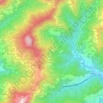
Name: Tolara topographic map, elevation, terrain.
Location: Tolara, Lumarzo, Genua, Ligurien, 16022, Italien (44.43062 9.09503 44.47062 9.13503)
Average elevation: 483 m
Minimum elevation: 221 m
Maximum elevation: 863 m
Make a donation
Gear up for your next adventure:
As an Amazon Associate, this site earns from qualifying purchases at no extra cost to you.
Other topographic maps
Click on a map to view its topography, its elevation and its terrain.
Genua
In den 1980er Jahren kam das Bevölkerungswachstum schließlich ins Stocken, um sich in den folgenden Jahren in eine „Bevölkerungsimplosion“ zu verwandeln. Von 816.000 Einwohnern 1971 sank die Population auf 610.000 im Jahre 2001 (das bedeutet eine Bevölkerungsminderung von 25 % innerhalb von 30 Jahren).…
Average elevation: 333 m
Camogli
Der Ortsname Camogli ist mit Sicherheit antiken Ursprungs, aber seine Herkunft ist ungewiss. Gemäß einer Erklärung liegt eine Ableitung von Camulo oder Camulio vor, einem sabinischen und etruskischen Namen für die Gottheit Mars, oder von Camolio, einer gallokeltischen Gottheit. Ein anderer…
Average elevation: 123 m
Make a donation
Gear up for your next adventure:
As an Amazon Associate, this site earns from qualifying purchases at no extra cost to you.
Genua
In den 1980er Jahren kam das Bevölkerungswachstum schließlich ins Stocken, um sich in den folgenden Jahren in eine „Bevölkerungsimplosion“ zu verwandeln. Von 816.000 Einwohnern 1971 sank die Population auf 610.000 im Jahre 2001 (das bedeutet eine Bevölkerungsminderung von 25 % innerhalb von 30 Jahren).…
Average elevation: 333 m
Make a donation
Gear up for your next adventure:
As an Amazon Associate, this site earns from qualifying purchases at no extra cost to you.
Make a donation
Gear up for your next adventure:
As an Amazon Associate, this site earns from qualifying purchases at no extra cost to you.
Santo Stefano d'Aveto
Santo Stefano d’Aveto liegt im Val d’Aveto, an den Ufern des Flusses Aveto. Die in einer Talmulde befindliche und vom 1804 Meter hohen Monte Maggiorasca dominierte Gemeinde liegt selbst auf einer Höhe von 1012 Metern über dem Meeresniveau und hat 982 Einwohner (Stand 31. Dezember 2024). Sie ist circa 76…
Average elevation: 1,166 m
Make a donation
Gear up for your next adventure:
As an Amazon Associate, this site earns from qualifying purchases at no extra cost to you.
Genua
In den 1980er Jahren kam das Bevölkerungswachstum schließlich ins Stocken, um sich in den folgenden Jahren in eine „Bevölkerungsimplosion“ zu verwandeln. Von 816.000 Einwohnern 1971 sank die Population auf 610.000 im Jahre 2001 (das bedeutet eine Bevölkerungsminderung von 25 % innerhalb von 30 Jahren).…
Average elevation: 333 m
Make a donation
Gear up for your next adventure:
As an Amazon Associate, this site earns from qualifying purchases at no extra cost to you.
Chiavari
Der Ort liegt zwischen Rapallo im Nordwesten und Sestri Levante im Südosten an der Küste des Golfo Tigullio an der Mündung des Flusses Entella und an der Bahnstrecke Pisa–Genova. Chiavari umfasst eine Fläche von etwa 20 km² und erstreckt sich vor dem Trebbia-Tal bis in eine Höhe von rund 50 m über dem…
Average elevation: 85 m
Make a donation
Gear up for your next adventure:
As an Amazon Associate, this site earns from qualifying purchases at no extra cost to you.
Make a donation
Gear up for your next adventure:
As an Amazon Associate, this site earns from qualifying purchases at no extra cost to you.
Make a donation
Gear up for your next adventure:
As an Amazon Associate, this site earns from qualifying purchases at no extra cost to you.