
Make a donation
Gear up for your next adventure:
As an Amazon Associate, this site earns from qualifying purchases at no extra cost to you.
Chester topographic map
Click on the map to display elevation.
Make a donation
Gear up for your next adventure:
As an Amazon Associate, this site earns from qualifying purchases at no extra cost to you.
Chester
Located at a low elevation between Philadelphia and Wilmington, Delaware, Chester experiences a humid subtropical climate (Cfa.) The hardiness zone is 7b. [1] Archived 2014-02-09 at the Wayback Machine
Make a donation
Gear up for your next adventure:
As an Amazon Associate, this site earns from qualifying purchases at no extra cost to you.
About this map
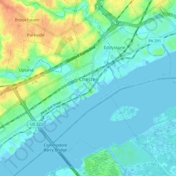
Name: Chester topographic map, elevation, terrain.
Location: Chester, Delaware County, Pennsylvania, 19013, United States (39.81731 -75.40808 39.87584 -75.34209)
Average elevation: 10 m
Minimum elevation: -2 m
Maximum elevation: 39 m
Make a donation
Gear up for your next adventure:
As an Amazon Associate, this site earns from qualifying purchases at no extra cost to you.