Geolocate

Murrayville topographic map

Click on the map to display elevation.

About this map

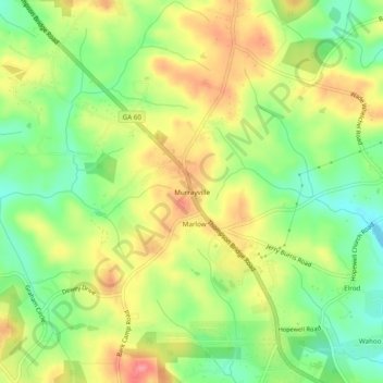
Name: Murrayville topographic map, elevation, terrain.

Location: Murrayville, Hall County, Georgia, 30564, United States (34.39871 -83.92574 34.43871 -83.88574)

Average elevation: 368 m

Minimum elevation: 325 m

Maximum elevation: 415 m

Other topographic maps

Click on a map to view its topography, its elevation and its terrain.

Gainesville

United States > Georgia > Hall County

Average elevation: 346 m

Deaton Creek

United States > Georgia > Hall County

Average elevation: 277 m

Oakwood

United States > Georgia > Hall County

Average elevation: 358 m

Gainesville

United States > Georgia > Hall County

Average elevation: 346 m

Flowery Branch

United States > Georgia > Hall County

Average elevation: 343 m

Lula

United States > Georgia > Hall County

Average elevation: 369 m

Lula

United States > Georgia > Hall County

Average elevation: 369 m

Gainesville

United States > Georgia > Hall County

Average elevation: 346 m

Gear up for your next adventure:

🧢Hiking Hat - Sun-protective and breathable hats for long treks
📷Outdoor Action Camera - Capture high-elevation views and rugged adventures
🧥Waterproof Jacket - Lightweight rain jackets for hiking and outdoor activities
💡Portable Camping Lamp - Rechargeable lamp for campsite lighting
👖Convertible Hiking Pants - Zip-off legs to adapt to changing weather conditions

As an Amazon Associate, this site earns from qualifying purchases at no extra cost to you.