Geolocate

Pittman topographic map

Click on the map to display elevation.

About this map

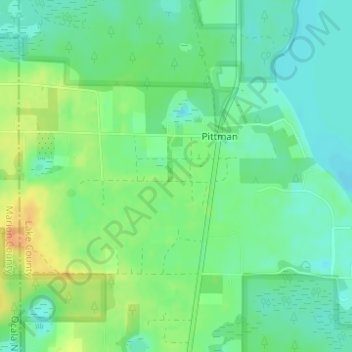
Name: Pittman topographic map, elevation, terrain.

Location: Pittman, Lake County, Florida, United States (28.98942 -81.65935 29.00445 -81.62902)

Average elevation: 26 m

Minimum elevation: 11 m

Maximum elevation: 49 m

Gear up for your next adventure:

🧢Sun Protection Cap - Breathable cap to protect from sun exposure
🧦Merino Wool Socks - Moisture-wicking comfort for long-distance hiking
🎒Backpack Rain Cover - External shield to keep your entire pack dry
🔋Lithium AA Batteries - Long-lasting power that performs in extreme cold
🧢Sun Hat - Wide-brim hat for sun protection

As an Amazon Associate, this site earns from qualifying purchases at no extra cost to you.