Geolocate

Jarod topographic map

Click on the map to display elevation.

About this map

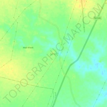
Name: Jarod topographic map, elevation, terrain.

Location: Jarod, Basoda Tahsil, Vidisha, Madhya Pradesh, India (23.90413 77.87052 23.94413 77.91052)

Average elevation: 410 m

Minimum elevation: 398 m

Maximum elevation: 420 m

Other topographic maps

Click on a map to view its topography, its elevation and its terrain.

Mudra

India > Madhya Pradesh > Basoda Tahsil > Gamakhar

Average elevation: 415 m

Baret

India > Madhya Pradesh > Basoda Tahsil

Average elevation: 407 m

Gear up for your next adventure:

🗺️Topographic Maps - Detailed maps to explore trails, mountains, and wilderness areas
🔋Solar Power Bank - Keep your GPS and devices charged during long outdoor trips
🥾Waterproof Hiking Shoes - Durable shoes for wet and rugged trails
🪑Ultralight Camping Stool - Compact seating for rest stops during long hikes
🧢Beanie Hat - Keep your head warm in cold weather

As an Amazon Associate, this site earns from qualifying purchases at no extra cost to you.