
Thank you for supporting this site ❤️
Make a donation
Make a donation
Gear up for your next adventure:
As an Amazon Associate, this site earns from qualifying purchases at no extra cost to you.
FuladShahr topographic map
Click on the map to display elevation.
Thank you for supporting this site ❤️
Make a donation
Make a donation
Gear up for your next adventure:
As an Amazon Associate, this site earns from qualifying purchases at no extra cost to you.
About this map
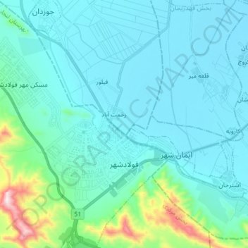
Name: FuladShahr topographic map, elevation, terrain.
Location: FuladShahr, بخش مرکزی, Lenjan County, Isfahan Province, Iran (32.44361 51.32030 32.56182 51.44190)
Average elevation: 1,710 m
Minimum elevation: 1,609 m
Maximum elevation: 2,377 m
Thank you for supporting this site ❤️
Make a donation
Make a donation
Gear up for your next adventure:
As an Amazon Associate, this site earns from qualifying purchases at no extra cost to you.
Other topographic maps
Click on a map to view its topography, its elevation and its terrain.
Chamgordan
Iran > Isfahan Province > Lenjan County > دهستان خرم رود > Chamgordan
Average elevation: 1,727 m