Geolocate

Bitkine topographic map

Click on the map to display elevation.

About this map

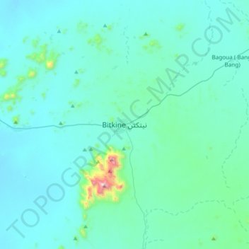
Name: Bitkine topographic map, elevation, terrain.

Location: Bitkine, Guéra, Chad (11.82111 18.05768 12.14111 18.37768)

Average elevation: 482 m

Minimum elevation: 381 m

Maximum elevation: 1,582 m

Gear up for your next adventure:

🚲MTB Frame Bag - Carry tools and maps directly on your bicycle frame
🧭Orienteering Kit - Tools for map reading and navigation in the wild
🧦Hiking Socks - Moisture-wicking and comfortable socks for long hikes
🧤Rechargeable Heated Gloves - Extreme warmth for Canadian winter expeditions
🥾Light Hiking Boots - Lightweight and comfortable boots for day hikes

As an Amazon Associate, this site earns from qualifying purchases at no extra cost to you.