
Thank you for supporting this site ❤️
Make a donation
Make a donation
Gear up for your next adventure:
As an Amazon Associate, this site earns from qualifying purchases at no extra cost to you.
Nättraby topographic map
Click on the map to display elevation.
Thank you for supporting this site ❤️
Make a donation
Make a donation
Gear up for your next adventure:
As an Amazon Associate, this site earns from qualifying purchases at no extra cost to you.
About this map
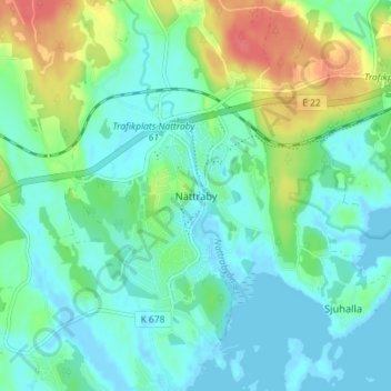
Name: Nättraby topographic map, elevation, terrain.
Location: Nättraby, Karlskrona kommun, Blekinge County, 370 24, Sweden (56.18030 15.51520 56.22030 15.55520)
Average elevation: 15 m
Minimum elevation: -2 m
Maximum elevation: 55 m
Thank you for supporting this site ❤️
Make a donation
Make a donation
Gear up for your next adventure:
As an Amazon Associate, this site earns from qualifying purchases at no extra cost to you.