
Make a donation
Gear up for your next adventure:
As an Amazon Associate, this site earns from qualifying purchases at no extra cost to you.
Sanmenxia City topographic map
Click on the map to display elevation.
Make a donation
Gear up for your next adventure:
As an Amazon Associate, this site earns from qualifying purchases at no extra cost to you.
Sanmenxia City
Sanmenxia is located in western Henan on the southern (right) bank of the Yellow River, and is surrounded on three sides by mountains, with elevations generally increasing from northeast to southwest. Most of the prefecture is at an altitude of 300 to 1,500 metres (980 to 4,920 ft), although the highest peak in the province, at 2,413.8 metres (7,919 ft), is located in Lingbao. The prefecture is at the intersection of Henan, Shanxi, and Shaanxi provinces, bordering Luoyang to the east, Nanyang to the south, Weinan (Shaanxi) to the west, and Yuncheng (Shanxi) to the north across the Yellow River.
Make a donation
Gear up for your next adventure:
As an Amazon Associate, this site earns from qualifying purchases at no extra cost to you.
About this map
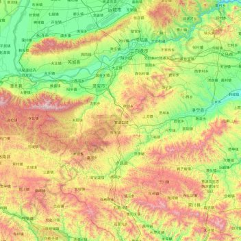
Name: Sanmenxia City topographic map, elevation, terrain.
Location: Sanmenxia City, Henan, China (33.54968 110.35511 35.08418 112.02556)
Average elevation: 842 m
Minimum elevation: 206 m
Maximum elevation: 2,307 m
Make a donation
Gear up for your next adventure:
As an Amazon Associate, this site earns from qualifying purchases at no extra cost to you.
Other topographic maps
Click on a map to view its topography, its elevation and its terrain.
Make a donation
Gear up for your next adventure:
As an Amazon Associate, this site earns from qualifying purchases at no extra cost to you.