Geolocate

Moody topographic map

Click on the map to display elevation.

About this map

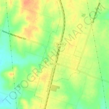
Name: Moody topographic map, elevation, terrain.

Location: Moody, McLennan County, Texas, United States (31.29389 -97.36901 31.32828 -97.35166)

Average elevation: 235 m

Minimum elevation: 211 m

Maximum elevation: 254 m

Other topographic maps

Click on a map to view its topography, its elevation and its terrain.

Elm Mott

United States > Texas > McLennan County

Average elevation: 156 m

Hewitt

United States > Texas > McLennan County > Hewitt > Hewitt

Average elevation: 189 m

Bruceville-Eddy

United States > Texas > McLennan County

Average elevation: 198 m

Waco

United States > Texas > McLennan County > Waco

Average elevation: 150 m

Gear up for your next adventure:

💡Portable Camping Lamp - Rechargeable lamp for campsite lighting
🎒Backpack Rain Cover - External shield to keep your entire pack dry
🧼Travel Hand Sanitizer - Keep hands clean when water is scarce
🥾Trail Hiking Shoes - Durable shoes designed for rugged trails
🧥Thermal Layer - Insulating layer for cold outdoor conditions

As an Amazon Associate, this site earns from qualifying purchases at no extra cost to you.