Geolocate

Philippi topographic map

Click on the map to display elevation.

Philippi

Throughout its history, Philippi has suffered from floods because of its proximity to the river and the relatively low elevation of most of the town. The most damaging of these came in November 1985. The town has since adopted a flood plain management plan.

Wikipedia (CC-BY-SA 3.0)

About this map

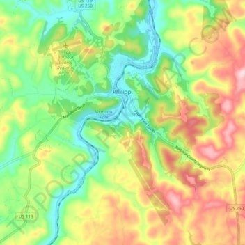
Name: Philippi topographic map, elevation, terrain.

Location: Philippi, Barbour County, West Virginia, 26416, United States (39.10595 -80.07430 39.17992 -79.98951)

Average elevation: 490 m

Minimum elevation: 388 m

Maximum elevation: 626 m

Other topographic maps

Click on a map to view its topography, its elevation and its terrain.

Audra

United States > West Virginia > Barbour County

Average elevation: 572 m

Gear up for your next adventure:

🎒Fully Waterproof Backpack - Total protection for photography gear and electronics
🧼Travel Hand Sanitizer - Keep hands clean when water is scarce
🔥Camping Stove - Portable stoves to cook outdoors with ease
🔦LED Flashlight - Powerful and long-lasting flashlight for camping and emergencies
👟Leg Gaiters - Keep debris, mud, and snow out of your boots

As an Amazon Associate, this site earns from qualifying purchases at no extra cost to you.