Geolocate

Santa Maria topographic map

Click on the map to display elevation.

About this map

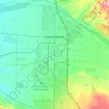
Name: Santa Maria topographic map, elevation, terrain.

Location: Santa Maria, Santa Barbara County, California, USA (34.87553 -120.50841 34.98924 -120.35434)

Average elevation: 86 m

Minimum elevation: 30 m

Maximum elevation: 272 m

Gear up for your next adventure:

🔭Compact Monocular - One-handed bird watching and trail spotting
🧢Hiking Hat - Sun-protective and breathable hats for long treks
🧥Softshell Hiking Jacket - The perfect balance of wind protection and breathability
🧭Orienteering Kit - Tools for map reading and navigation in the wild
👟Leg Gaiters - Keep debris, mud, and snow out of your boots

As an Amazon Associate, this site earns from qualifying purchases at no extra cost to you.