Geolocate

Cuenca topographic map

Click on the map to display elevation.

About this map

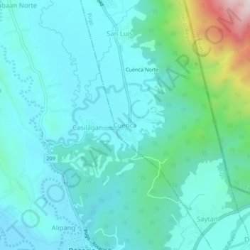
Name: Cuenca topographic map, elevation, terrain.

Location: Cuenca, Pugo, La Union, Ilocos Region, 2508, Philippines (16.23009 120.47485 16.27009 120.51485)

Average elevation: 209 m

Minimum elevation: 109 m

Maximum elevation: 690 m

Gear up for your next adventure:

🧭GPS Tracker - Track your location in remote areas safely
🧶550 Survival Paracord - Versatile utility cord for emergency repairs and rigging
🕯️Camping Lantern - Illuminates your entire campsite with high-efficiency LEDs
🔭Compact Monocular - One-handed bird watching and trail spotting
🛶Kayak Accessories - Essential gear for safe and fun kayaking adventures

As an Amazon Associate, this site earns from qualifying purchases at no extra cost to you.