
Terrassa topographic map
Click on the map to display elevation.
Terrassa
The city is located in the Catalan Prelitoral depression (Depressió Prelitoral), at the feet of the Prelitoral mountain range (natural reserve of Sant Llorenç del Munt [ca]) and the average altitude of the city is 277 meters above sea level. It is 20 and 18 kilometres from Barcelona and Montserrat respectively.
About this map
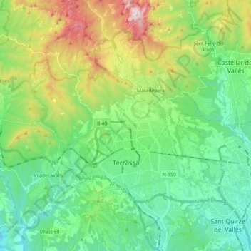
Name: Terrassa topographic map, elevation, terrain.
Location: Terrassa, Vallès Occidental, Barcelona, Catalonia, Spain (41.51630 1.94358 41.64872 2.06882)
Average elevation: 383 m
Minimum elevation: 93 m
Maximum elevation: 1,090 m