Geolocate

Les topographic map

Click on the map to display elevation.

About this map

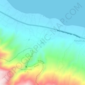
Name: Les topographic map, elevation, terrain.

Location: Les, Buleleng, Bali, Lesser Sunda Islands, 81173, Indonesia (-8.16276 115.34785 -8.12276 115.38785)

Average elevation: 187 m

Minimum elevation: 0 m

Maximum elevation: 799 m

Other topographic maps

Click on a map to view its topography, its elevation and its terrain.

Keberan

Indonesia > Bali > Buleleng

Average elevation: 275 m

Gerokgak

Indonesia > Bali > Buleleng

Average elevation: 197 m

Kubutambahan

Indonesia > Bali > Buleleng

Average elevation: 610 m

Gear up for your next adventure:

🥾Hiking Leggings - Comfortable leggings for outdoor activities
🥾Light Hiking Boots - Lightweight and comfortable boots for day hikes
🧦Hiking Liner Socks - Thin base layer to prevent friction and blisters
🧭GPS Outdoor Watch - Smart watch for navigation and fitness tracking in nature
Camping Essentials - All-in-one gear for a comfortable camping trip

As an Amazon Associate, this site earns from qualifying purchases at no extra cost to you.