
Make a donation
Gear up for your next adventure:
As an Amazon Associate, this site earns from qualifying purchases at no extra cost to you.
Swan Lake topographic map
Click on the map to display elevation.
Make a donation
Gear up for your next adventure:
As an Amazon Associate, this site earns from qualifying purchases at no extra cost to you.
Swan Lake
The Swan Lake drainage basin covers 3,880 square miles (10,000 km2) and extends into the province of Saskatchewan. It is located between the Duck Mountains and the Porcupine Hills. Two major rivers discharge into Swan Lake from the basin, the Swan River and the Woody River. Other topographic features include Thunder Hill, the Swan River valley and plain, the two river's many tributaries, and Swan Lake and its surrounding delta wetland area. In addition to Swan Lake, there are approximately 30 smaller lakes in the basin; the major ones being, Lac La Course, Madge Lake, Sarah Lake, Wellman Lake, Whitefish Lake, and Woody Lake. Land elevations vary from 2,600 and 2,300 feet above sea level in the Porcupine Hills and Duck Mountains respectively, to 851 feet above sea level at Swan Lake.
Make a donation
Gear up for your next adventure:
As an Amazon Associate, this site earns from qualifying purchases at no extra cost to you.
About this map
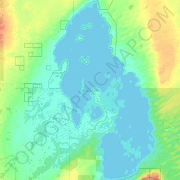
Name: Swan Lake topographic map, elevation, terrain.
Location: Swan Lake, Unorganized Division No. 19, Manitoba, Canada (52.34980 -100.86690 52.64234 -100.59182)
Average elevation: 269 m
Minimum elevation: 257 m
Maximum elevation: 318 m
Unorganized Division No. 19 trails, hiking, mountain biking, running and outdoor activities
Make a donation
Gear up for your next adventure:
As an Amazon Associate, this site earns from qualifying purchases at no extra cost to you.
Other topographic maps
Click on a map to view its topography, its elevation and its terrain.
Make a donation
Gear up for your next adventure:
As an Amazon Associate, this site earns from qualifying purchases at no extra cost to you.