Geolocate

Lawi topographic map

Click on the map to display elevation.

About this map

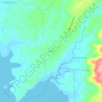
Name: Lawi topographic map, elevation, terrain.

Location: Lawi, Jordan, Guimaras, Western Visayas, Philippines (10.53984 122.51640 10.57984 122.55640)

Average elevation: 30 m

Minimum elevation: -1 m

Maximum elevation: 159 m

Other topographic maps

Click on a map to view its topography, its elevation and its terrain.

Tatlong Pulo Beach

Philippines > Guimaras > Jordan

Average elevation: 9 m

Gear up for your next adventure:

🧶550 Survival Paracord - Versatile utility cord for emergency repairs and rigging
🥾Hiking Leggings - Comfortable leggings for outdoor activities
🔦LED Headtorch - Bright and durable light for night activities
🥾Trail Hiking Socks - Comfortable socks to prevent blisters and fatigue
🔋Solar Power Bank - Keep your GPS and devices charged during long outdoor trips

As an Amazon Associate, this site earns from qualifying purchases at no extra cost to you.