Geolocate

Demirtaş topographic map

Click on the map to display elevation.

About this map

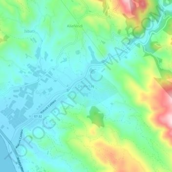
Name: Demirtaş topographic map, elevation, terrain.

Location: Demirtaş, Alanya, Antalya, Mediterranean Region, 07430, Turkey (36.40702 32.17182 36.44702 32.21182)

Average elevation: 86 m

Minimum elevation: -2 m

Maximum elevation: 326 m

Other topographic maps

Click on a map to view its topography, its elevation and its terrain.

Tosmur

Turkey > Alanya

Average elevation: 13 m

Çarşı Mahallesi

Turkey > Alanya

Average elevation: 20 m

Cikcilli

Turkey > Alanya

Average elevation: 96 m

Tophane Mahallesi

Turkey > Alanya

Average elevation: 17 m

Çarşı Mahallesi

Turkey > Alanya

Average elevation: 19 m

Gear up for your next adventure:

🛶Kayak Accessories - Essential gear for safe and fun kayaking adventures
🧢Outdoor Cap - Protective cap for sun and rain during hikes
🔥Emergency Fire Starter - Reliable ignition source for all weather conditions
🌡️Emergency Mylar Blankets - Compact thermal protection for unexpected nights outdoors
🦌Outdoor Trail Camera - Monitor wildlife activity near your favorite spots

As an Amazon Associate, this site earns from qualifying purchases at no extra cost to you.