
Setul topographic map
Click on the map to display elevation.
About this map
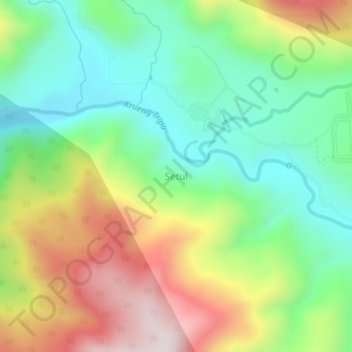
Name: Setul topographic map, elevation, terrain.
Location: Setul, Tripe Jaya, Gayo Lues, Aceh, Sumatra, Indonesia (4.13485 96.95522 4.17485 96.99522)
Average elevation: 810 m
Minimum elevation: 540 m
Maximum elevation: 1,236 m
Other topographic maps
Click on a map to view its topography, its elevation and its terrain.
Blangkejeren
Blangkejeren is located in the upper reaches of the Tripa River Basin, at an elevation of approximately 920 metres above sea level. It is a highland town nestled in the Bukit Barisan mountain range of Sumatra.
Average elevation: 1,403 m