
Thank you for supporting this site ❤️
Make a donation
Make a donation
Gear up for your next adventure:
As an Amazon Associate, this site earns from qualifying purchases at no extra cost to you.
Incino topographic map
Click on the map to display elevation.
Thank you for supporting this site ❤️
Make a donation
Make a donation
Gear up for your next adventure:
As an Amazon Associate, this site earns from qualifying purchases at no extra cost to you.
About this map
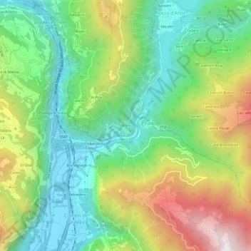
Name: Incino topographic map, elevation, terrain.
Location: Incino, Arsiè, Provincia di Belluno, Veneto, 32030, Italia (45.91425 11.72130 45.95425 11.76130)
Average elevation: 585 m
Minimum elevation: 189 m
Maximum elevation: 1,276 m
Thank you for supporting this site ❤️
Make a donation
Make a donation
Gear up for your next adventure:
As an Amazon Associate, this site earns from qualifying purchases at no extra cost to you.