
Km 41 - Colombia topographic map
Click on the map to display elevation.
About this map
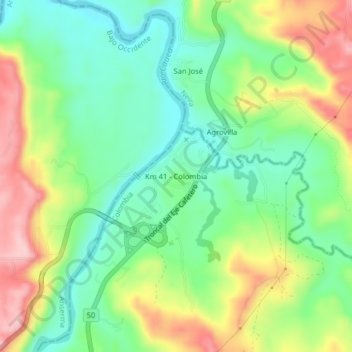
Name: Km 41 - Colombia topographic map, elevation, terrain.
Average elevation: 850 m
Minimum elevation: 772 m
Maximum elevation: 972 m
Other topographic maps
Click on a map to view its topography, its elevation and its terrain.
Comuna Atardeceres
Colombia > Caldas > Manizales > Perímetro Urbano Manizales
Average elevation: 1,913 m
Comuna Ecoturística Cerro de Oro
Colombia > Caldas > Manizales > Perímetro Urbano Manizales
Average elevation: 2,174 m
Comuna Universitaria
Colombia > Caldas > Manizales > Perímetro Urbano Manizales
Average elevation: 1,977 m
Comuna Ecoturística Cerro de Oro
Colombia > Caldas > Manizales > Perímetro Urbano Manizales
Average elevation: 2,174 m
Comuna Universitaria
Colombia > Caldas > Manizales > Perímetro Urbano Manizales
Average elevation: 1,977 m
Comuna Ecoturística Cerro de Oro
Colombia > Caldas > Manizales > Perímetro Urbano Manizales
Average elevation: 2,174 m