Geolocate

Piz Boè topographic map

Click on the map to display elevation.

Piz Boè

Piz Boè is the highest mountain of the Sella group, a mountain range in the Dolomites, Italy. It has an elevation of 3,152 metres (10,341 ft).

Wikipedia (CC-BY-SA 3.0)

About this map

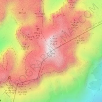
Name: Piz Boè topographic map, elevation, terrain.

Location: Piz Boè, Corvara in Badia - Corvara, Pustertal - Val Pusteria, South Tyrol, Trentino – Alto Adige/Südtirol, Italy (46.50889 11.82830 46.50899 11.82840)

Average elevation: 2,664 m

Minimum elevation: 1,971 m

Maximum elevation: 3,125 m

Gear up for your next adventure:

🧦Outdoor Socks - Durable socks designed for hiking and outdoor sports
💧Reusable Water Bottle - Durable water bottles for hydration on trails
🦌Outdoor Trail Camera - Monitor wildlife activity near your favorite spots
Lightweight Camping Tent - Portable shelter optimized for Canadian backcountry camping
🪑Insulated Seat Pad - Protect your seat from cold rocks and wet logs

As an Amazon Associate, this site earns from qualifying purchases at no extra cost to you.