Geolocate

Picerno topographic map

Click on the map to display elevation.

About this map

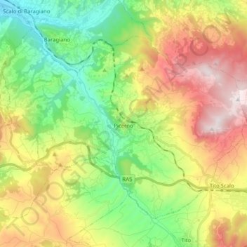
Name: Picerno topographic map, elevation, terrain.

Location: Picerno, Potenza, Basilicata, Italy (40.59394 15.55903 40.68502 15.71470)

Average elevation: 752 m

Minimum elevation: 343 m

Maximum elevation: 1,349 m

Other topographic maps

Click on a map to view its topography, its elevation and its terrain.

Agri

Italy > Basilicata > Potenza > San Martino d'Agri

Average elevation: 491 m

Gear up for your next adventure:

🛌Down Sleeping Bag - Superior warmth-to-weight ratio for cold nights
🧊Portable Cooler - Keep food and drinks cold during outdoor adventures
👖Convertible Hiking Pants - Zip-off legs to adapt to changing weather conditions
🚑Survival Whistle - Signal for help across long distances in mountains
🧦Crew Hiking Socks - Comfortable socks for long-distance hikes

As an Amazon Associate, this site earns from qualifying purchases at no extra cost to you.