Geolocate

Ceuta topographic map

Click on the map to display elevation.

About this map

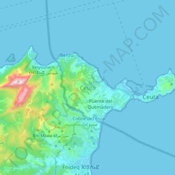
Name: Ceuta topographic map, elevation, terrain.

Location: Ceuta, Plazas de Soberanía, Spain (35.87086 -5.42195 35.91800 -5.27830)

Average elevation: 76 m

Minimum elevation: -1 m

Maximum elevation: 831 m

Gear up for your next adventure:

🥾Trekking Boots - Durable boots for long-distance trekking
🦌Outdoor Trail Camera - Monitor wildlife activity near your favorite spots
💧Hydration Bladder - Hands-free hydration solution for long treks
🔭Compact Monocular - One-handed bird watching and trail spotting
🔦LED Headlamp - Hands-free lighting for early morning starts or late finishes

As an Amazon Associate, this site earns from qualifying purchases at no extra cost to you.