
Make a donation
Gear up for your next adventure:
As an Amazon Associate, this site earns from qualifying purchases at no extra cost to you.
Triton topographic map
Click on the map to display elevation.
Make a donation
Gear up for your next adventure:
As an Amazon Associate, this site earns from qualifying purchases at no extra cost to you.
About this map
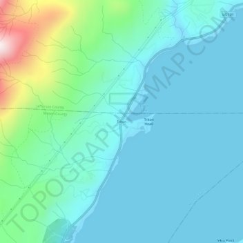
Name: Triton topographic map, elevation, terrain.
Location: Triton, Mason County, Washington, United States (47.58481 -123.00988 47.62481 -122.96988)
Average elevation: 122 m
Minimum elevation: -1 m
Maximum elevation: 711 m
Make a donation
Gear up for your next adventure:
As an Amazon Associate, this site earns from qualifying purchases at no extra cost to you.
Other topographic maps
Click on a map to view its topography, its elevation and its terrain.
Mount Skokomish Wilderness
United States > Washington > Mason County
Mount Skokomish Wilderness is located in the southeast corner of Olympic National Forest, just north of Lake Cushman. It consists of two long rocky ridges running roughly northeast to southwest. Elevations range from about 2,000 feet (609.6 m) to 6,434 feet (1,961.1 m) at the peak of Mount Skokomish on the…
Average elevation: 1,058 m
Make a donation
Gear up for your next adventure:
As an Amazon Associate, this site earns from qualifying purchases at no extra cost to you.