Geolocate

Bamo topographic map

Click on the map to display elevation.

About this map

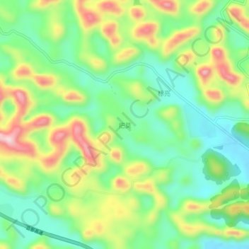
Name: Bamo topographic map, elevation, terrain.

Location: Bamo, Baise, Guangxi, China (23.12430 106.24100 23.16430 106.28100)

Average elevation: 890 m

Minimum elevation: 770 m

Maximum elevation: 1,081 m

Other topographic maps

Click on a map to view its topography, its elevation and its terrain.

Youjiang District

China > Guangxi > Baise

Average elevation: 532 m

Gear up for your next adventure:

🧊Portable Cooler - Keep food and drinks cold during outdoor adventures
🧳Compression Sacks - Maximize space in your backpack by shrinking gear
🥾Trekking Poles - Adjustable trekking poles to reduce knee stress and improve stability
🔦LED Flashlight - Powerful and long-lasting flashlight for camping and emergencies
🐕Hiking Dog Pack - Let your canine companion carry their own water and food

As an Amazon Associate, this site earns from qualifying purchases at no extra cost to you.