Geolocate

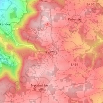
Ludwag topographic map

Click on the map to display elevation.

Ludwag

Ludwag liegt auf einer Anhöhe an der Straße, die von Scheßlitz nach Heiligenstadt führt. Unterhalb der Ortschaft liegt ein ausgedehnter stillgelegter Kalksteinbruch. Auf einem Berg in der Nähe von Ludwag befindet sich die Wallfahrtskirche Gügel. Benachbarte Ortschaften sind Neudorf, Poxdorf, Kübelstein und Zeckendorf.

Wikipedia (CC-BY-SA 3.0)

About this map

Name: Ludwag topographic map, elevation, terrain.

Location: Ludwag, Scheßlitz, Landkreis Bamberg, Bayern, 96110, Deutschland (49.93046 11.06658 49.97046 11.10658)

Average elevation: 511 m

Minimum elevation: 339 m

Maximum elevation: 575 m

Other topographic maps

Click on a map to view its topography, its elevation and its terrain.

96110

Deutschland > Bayern > Landkreis Bamberg > Scheßlitz

Average elevation: 407 m

Gear up for your next adventure:

💡Portable Camping Lamp - Rechargeable lamp for campsite lighting
🔦LED Headlamp - Hands-free lighting for early morning starts or late finishes
Camping Coffee Maker - Brew fresh coffee anywhere on the topographic map
🧴Bear Spray Holster - Quick-access carry for essential Canadian wilderness safety
💧Hydration Bladder - Hands-free hydration solution for long treks

As an Amazon Associate, this site earns from qualifying purchases at no extra cost to you.