Geolocate

Pyramids topographic map

Click on the map to display elevation.

About this map

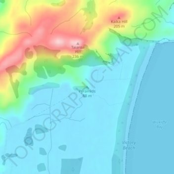
Name: Pyramids topographic map, elevation, terrain.

Location: Pyramids, Dunedin City, Otago, 9077, New Zealand (-45.82285 170.72133 -45.82275 170.72143)

Average elevation: 52 m

Minimum elevation: -1 m

Maximum elevation: 224 m

Other topographic maps

Click on a map to view its topography, its elevation and its terrain.

Logan Park

New Zealand > Otago > Dunedin City > Dunedin

Average elevation: 44 m

Waitati River

New Zealand > Otago > Dunedin City > Waitati

Average elevation: 259 m

Otago Harbour

New Zealand > Otago > Dunedin City > Dunedin

Average elevation: 113 m

Dunedin

New Zealand > Otago > Dunedin City

Average elevation: 143 m

Cragieburn

New Zealand > Otago > Dunedin City

Average elevation: 203 m

Gear up for your next adventure:

🥾Trail Hiking Shoes - Durable shoes designed for rugged trails
🩹Compact First Aid Kit - Pre-packed essentials for common trail injuries
🦶Anti-Blister Balm - Prevents friction and hotspots during long ascents
🥫Freeze-Dried Meals - Lightweight, high-calorie nutrition for multi-day treks
🏃Hydration Running Vest - Carry water and maps close to your body for speed

As an Amazon Associate, this site earns from qualifying purchases at no extra cost to you.