Geolocate

Dursley topographic map

Click on the map to display elevation.

About this map

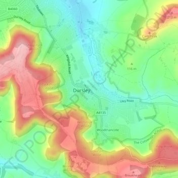
Name: Dursley topographic map, elevation, terrain.

Location: Dursley, Stroud, Gloucestershire, England, United Kingdom (51.66878 -2.36756 51.69396 -2.32036)

Average elevation: 117 m

Minimum elevation: 45 m

Maximum elevation: 214 m

Gear up for your next adventure:

🩹Compact First Aid Kit - Pre-packed essentials for common trail injuries
🧥Waterproof Pants - Keep dry during rainy hiking conditions
🥾Approach Shoes - Shoes designed for climbing approaches and rugged trails
🥾Trekking Poles - Adjustable trekking poles to reduce knee stress and improve stability
❄️Traction Ice Cleats - Slip-on spikes for icy trails and winter hiking

As an Amazon Associate, this site earns from qualifying purchases at no extra cost to you.