
Make a donation
Gear up for your next adventure:
As an Amazon Associate, this site earns from qualifying purchases at no extra cost to you.
Zaventem topographic map
Click on the map to display elevation.
Make a donation
Gear up for your next adventure:
As an Amazon Associate, this site earns from qualifying purchases at no extra cost to you.
About this map
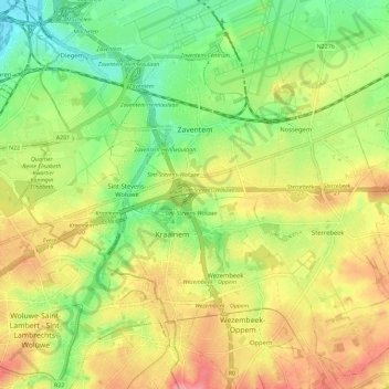
Name: Zaventem topographic map, elevation, terrain.
Location: Zaventem, Halle-Vilvoorde, Flemish Brabant, Belgium (50.83430 4.42087 50.90246 4.53639)
Average elevation: 57 m
Minimum elevation: 13 m
Maximum elevation: 105 m
Make a donation
Gear up for your next adventure:
As an Amazon Associate, this site earns from qualifying purchases at no extra cost to you.
Other topographic maps
Click on a map to view its topography, its elevation and its terrain.
Make a donation
Gear up for your next adventure:
As an Amazon Associate, this site earns from qualifying purchases at no extra cost to you.
La Fresnaye
Belgium > Flemish Brabant > Halle-Vilvoorde > Buizingen > Ziekendries
Average elevation: 72 m
Make a donation
Gear up for your next adventure:
As an Amazon Associate, this site earns from qualifying purchases at no extra cost to you.
Lac de Genval - Meer van Genval
Belgium > Flemish Brabant > Halle-Vilvoorde > Overijse > Genval
Average elevation: 80 m
Make a donation
Gear up for your next adventure:
As an Amazon Associate, this site earns from qualifying purchases at no extra cost to you.
Make a donation
Gear up for your next adventure:
As an Amazon Associate, this site earns from qualifying purchases at no extra cost to you.