
Make a donation
Gear up for your next adventure:
As an Amazon Associate, this site earns from qualifying purchases at no extra cost to you.
McKenna topographic map
Click on the map to display elevation.
Make a donation
Gear up for your next adventure:
As an Amazon Associate, this site earns from qualifying purchases at no extra cost to you.
About this map
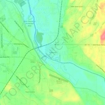
Name: McKenna topographic map, elevation, terrain.
Location: McKenna, Pierce County, Washington, 98558, United States (46.91482 -122.57651 46.95482 -122.53651)
Average elevation: 109 m
Minimum elevation: 81 m
Maximum elevation: 158 m
Make a donation
Gear up for your next adventure:
As an Amazon Associate, this site earns from qualifying purchases at no extra cost to you.
Other topographic maps
Click on a map to view its topography, its elevation and its terrain.
Tacoma
United States > Washington > Pierce County
Tacoma is at 47°14′29″N 122°27′34″W / 47.24139°N 122.45944°W / 47.24139; -122.45944 (47.241371, –122.459389). Its official elevation is 381 feet (116 m), varying between sea level and about 500 feet (150 m).
Average elevation: 67 m