Geolocate

Manduria topographic map

Click on the map to display elevation.

About this map

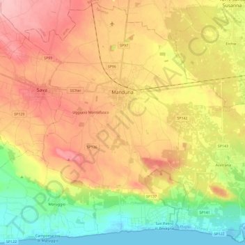
Name: Manduria topographic map, elevation, terrain.

Location: Manduria, Taranto, Apulia, 74024, Italy (40.29458 17.54255 40.46541 17.77055)

Average elevation: 70 m

Minimum elevation: -2 m

Maximum elevation: 139 m

Other topographic maps

Click on a map to view its topography, its elevation and its terrain.

Torre Colimena

Italy > Apulia > Taranto > Manduria

Average elevation: 3 m

Chiatona

Italy > Apulia > Taranto > Palagiano

Average elevation: 5 m

Gear up for your next adventure:

🧥Softshell Hiking Jacket - The perfect balance of wind protection and breathability
🔭Compact Binoculars - Lightweight optics for scouting trails and wildlife
🏃Hydration Running Vest - Carry water and maps close to your body for speed
🥾Mountain Trail Shoes - High-traction shoes for mountain trails
🍽️Titanium Camping Spork - Ultralight and indestructible eating utensil

As an Amazon Associate, this site earns from qualifying purchases at no extra cost to you.